Many women face a complex set of family, workplace and other social roles that they must balance against their own individual health and education interests and needs. We have found throughout the past four years of working to train women to use telemedicine systems for managing their health that most women care for their own health as well as the health and welfare of their families. This has a broad cumulative societal impact because of the compounding effects of the magnitude of each woman's daily dance on their lives, long-term health status, and participation in the workforce. Through training nearly 150 women in one-on-one settings to learn how to use ICTs for managing their health, we gained insights into society's needs for better understanding of the context within which women are learning and applying technology skills in their daily lives.
On a practical level, our efforts show the importance of providing access to ICTs in multiple settings. In particular, we find that settings where women use ICTs need to support them to manage their social roles as caregivers and workers with their individual health concerns. We also suggest that more attention to the socially-bounded movements of women is needed.
The women we trained during the past four years were extremely mobile, navigating multiple work and social environments often relying on more than one mode of transportation, despite the fact that most were poor, under-employed and disconnected from mainstream societal resources to advance their educations. We taught them to use e-health communication systems that were static in nature. Underlying this approach for improving patient-health care provider communications was a notion that women’s lives are situated primarily in their homes. Because of this, most of the emphasis placed on improving their ICT skills related to their potential to use computers at home and with the support of family members. However, upon working directly with women, we found that relying on the home as the primary and sole locus of computer access and use proved to be an ineffective strategy for many of the women with whom we worked.
Gaining a better understanding of the multiple contexts of women’s lives is an important step in overcoming incorrect assumptions about the geographies of their every day lives. Our societal failure to do so will render many rising health care policies ineffective at improving women's health (as well as their educational opportunities and economic livelihoods). We have found that health care providers are especially attuned to the challenges of communicating across language and cultural barriers. However, we suggest that as of yet this has not translated into effective strategies for overcoming barriers to digital inclusion with regard to managing health and the interrelated concerns that are at the forefront of many women's concerns.
Most of the women with whom we worked were enthusiastic e-technology learners and users, and recognized the potential of e-health systems to improve the quality of their health care. For some, it represented better care than they could receive in person because of the potential to reduce office visits and improve monitoring health conditions. It also represented one of the few opportunities that they encountered to gain e-technology skills they thought were important to advance their educations and work opportunities. Their efforts to use e-health systems meant that they worked to overcome language, access, safety and surveillance, and educational barriers in order to gain a foothold in the rapidly emerging e-health care paradigm.
In our new post on ITSRG Working Papers, we suggest that it is incumbent upon health care providers and technology specialists to account for women’s experiences using these systems to design ones that take into account their particular challenges and concerns. The rapid rate of improvement in mobile technologies holds promise for many, since transportability would seem to address many of the access issues we observed. More direct connections between technology and literacy training seem essential for improving the use of systems among women whose life experiences are situated at the societal margins. Approaches for implementing e-health monitoring systems also need to attend to the safety, privacy and empowerment concerns of women if we truly expect to improve their health outlooks using e-technologies.
Caroline Guigar
Michele Masucci
Temple University
|
0 Comments
On behalf of the Information Technology and Society Research Group of Temple University, we wish to express sincere thanks to the geo-blogging community for following ITSpace during the past six weeks as we have called attention to growing trend for citizens to share spatial information using web 2.0 applications. In particular, we wish to give a special thanks to the folks at Very Spatial for calling our series to the attention of their readers and pod cast audience. We are grateful for the insightful comments shared by the professional geographers across the country and members of online map user communities. Thank you also for the contributions of guest authors David Organ and Paul Schroeder. We will continue to welcome guest authors to post new discussions, so please do not hesitate to contact us about new post ideas related to the theme of Citizen Cartographers in the future. BITS Summer Program 2008 is underway throughout the month of July. This year we are providing students with research and field experiences and information technology skills in mapping historic markers related to the African American experience in Philadelphia. 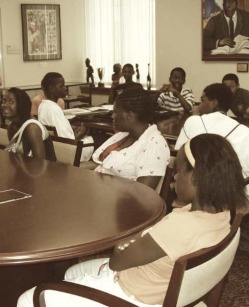 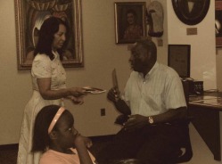 This summer, our students are focused on creating web-interactive maps of the entire marker collection documented by Dr. Blockson. Dr. Blockson has spent a great deal of time helping our students to understand the politics of marking by sharing some of the stories related to how and why specific settings are ultimately chosen to receive an official state historical marker. They have found that there is no single consolidated listing of markers, since more than one institution has programs to place markers at historical sites. And, since the various marker programs do not create meta-tags denoting categories for inclusion, it is difficult to search for maps of markers online. Here is the map one of our students, Hazreena Ali, has created drawing from Mr. Blockson's book detailing sites related to African American history designated by the State of Pennsylvania to be of interest within Philadelphia. One interesting example of a setting that has been given a state historic marker is the Legendary Blue Horizon, located on North Broad Street, just a few blocks from Temple University's Main Campus. Many of the greatest boxers of the last century have fought and trained at the Blue Horizon. Surprisingly little information about it is found online, and even less is noted on the marker outside. Our approach for providing students with an understanding of its historical and cultural significance within the African American community of Philadelphia and beyond has been to visit, photo-document, and map the location during the past four years. Through this process, our students have come to understand that it is a living legacy that continues to host world-renowned boxing events, and that its owners are striving to compile archives of its historical significance and share them with the public. Newspaper clippings are framed behind the venue manager's desk, shown here in a photo taken by students in the BITS Program during the summer of 2006. Over the past year, various Web 2.0 technology platforms have begun to provide its users with the ability to connect content they have created with a location, thus enabling not only keyword searches but location-based searches. This experience has been further enhanced through geoRSS feeds and geotags which integrate technologies such as Twitter and Flickr with online mapping sites such as Google and Yahoo Maps. Thanks to Temple's IT and Society Research Group (ITSRG) for creating a space for "citizen cartographers" to show their work. I hope this opportunity continues beyond June into the coming months. 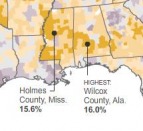 Gas Maps Part 2 examines a map published by The New York Times on June 9th, 2008 called "The Varying Impact of Gas Prices" that has been in heavy Internet circulation during the past week. It shows the locations where consumers spend the highest percentage of their income on gasoline. In general, poor rural counties in the Southeast and Appalachia; along the Mississippi River; in Texas, Oklahoma and New Mexico and in the Northern Rocky Mountains states are fairing the worst despite the fact that urban centers on both coasts have higher per gallon costs. The place that earned the dubious distinction of the highest gasoline costs as a percent of income is Wilcox County, Alabama. There, residents pay on average 16% of their income on gas at current prices. The rest of the counties in the Black Belt along the Alabama River share a similar impact.  Gee's Bend once served as a safe haven in the racially tumultuous environs of west Alabama for Dr. Martin Luther King, Jr. and other local and regional civil rights activists to reside and organize prior to the historic march for voting rights from Selma to Montgomery in 1965. Their struggles and efforts are embedded in the memories of the people and local institutions of Wilcox County and Gee's Bend. Forty three years later, we are reminded that regional and economic disparities and institutionalized forms of racial inequality persist in the social landscape of American society. 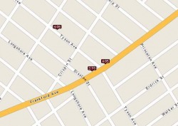 Soaring gasoline costs have prompted keen consumer interest in finding the locations of service stations that have the lowest prices per gallon. The problem is an interesting one from a geographic perspective. The key to saving money is to find the lowest cost source of gasoline that is located as close as possible to a person's normal driving rounds. This allows the consumer to maximize savings by minimizing the cost of driving extra distances to search for cheap gas. Web maps have proliferated to fill in local knowledge of where gasoline is cheapest just-in-time for a fuel-up.  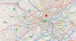 Openstreetmap.org and Wikimapia.org are two wiki-enabled collaborative mapping applications that support web user defined geographic content anchored to a common global geo-coordinate system. (ITSRG is among the handful of collaborators for the Philadelphia region, shown in the map above.) Wikimapia - Temple Town, North PhiladelphiaE-Pumpkin Carve Google Maps Mash Up
View Larger Map  The Huffington Post is currently ranked as Technorati's number one authority blog. This means that it has more blogs that link to it than any others according to Technorati's links count. This distinction makes the recent addition of a separate page on Green News and Opinions within The Huffington Post particularly noteworthy to the environmental research community. While The City of Brotherly Love observes a near meltdown of its nationally touted city Wi-Fi initiative called Wireless Philadelphia, the Los Angeles Fire Department marks over 1,500,000 visitors to its blog. The LAFD Blog is not just any online information resource. It is a fully interactive communication and response system built on a series of free web, cross connecting 2.0 applications that supports real-time information flows through the network nodes. Integrated features include live Twitter Tweets, Youtube videos, Blogtalk Radio broadcasts, and live news feeds related to fire safety and prevention, fire events and statuses, and other emergency management news from around the region and country. The current post provides basic information about Twitter, a popular mini-blog and message system application. Map of Wildfires in the Los Angeles Region, October 2007
View Larger Map |
ITSpace: Geographies  Flickr BITSArchives
November 2011

BlogrollBest Green Blogs Categories
All
|
 RSS Feed
